

• Route planner
  • My activities
  • Blog
  • FAQ
Instagram Buy me a coffee
Connect with Strava
Back to the app

Frequently asked questions

Quick answers to the questions we get most often.

General

RouteCycle started from a simple problem I had myself. I love exploring the area where I ride. My perfect day is a 100 km ride to a beautiful castle and back, on quiet roads I have never ridden before. After many years and many kilometers in the saddle, I noticed the same thing again and again: every other route planner — Komoot, Strava, Garmin, RideWithGPS — only finds the shortest or fastest path between two points. None of them help with the two things that really make a ride great: avoiding traffic and finding sights worth riding to.

The real problem is how these apps work. You drop pins on the map, and the app picks roads between them. To make the route better, you add more pins in the middle and try to push it away from bad roads. But you pick those middle pins blind: if you don't know the area, you can't tell if the road you are choosing is nice to ride or not. Sometimes you get lucky. Often you don't — and you only find out when you are already on the road. Or you spend a lot of time before the ride: looking at Google Maps, checking Street View, comparing heatmaps, and so on. For me, this is annoying. I want to ride my bike, not plan rides for hours.

RouteCycle asks a different question. Not "what is the fastest way from A to B?" but "what is a great ride?" It picks small, quiet roads, even if they are longer. It looks for sights, water springs, and cafes along the way. It can build a loop that starts and ends at your home. And it can send you on roads you have never ridden before, so every weekend feels new instead of the same loop you have already done ten times.

That last part is the "Explore new roads" idea, and I want to explain it. The goal is not to ride every small street near your house — that is boring, not fun. The goal is to find new good roads in places you have not been to yet: a quiet country road over the next hill, a forest road you did not know about, a new way to reach a castle you have already visited. RouteCycle picks roads that are both new to you and nice to ride. So your weekend ride still feels like a real ride — just in a new place.
Read more

You probably don't need RouteCycle if: you ride the same route again and again, you train on the same hill, you already know your area very well and can build a good route fast, or you just need the shortest way from A to B. For these cases, any popular service like Garmin or Komoot is enough.

RouteCycle is for you if: you want to discover new sights and new roads, and you don't want to spend time planning where to go. Just open the app, set your distance, and ride.

Trips and bikepacking are another big one. Planning a multi-day route by hand can take many hours — picking quiet roads, sights, water points, places to sleep, and then stitching it all together day by day. My goal is to make RouteCycle build a great trip route in one click. We are not fully there yet, but this is the direction the project is heading.

Read more

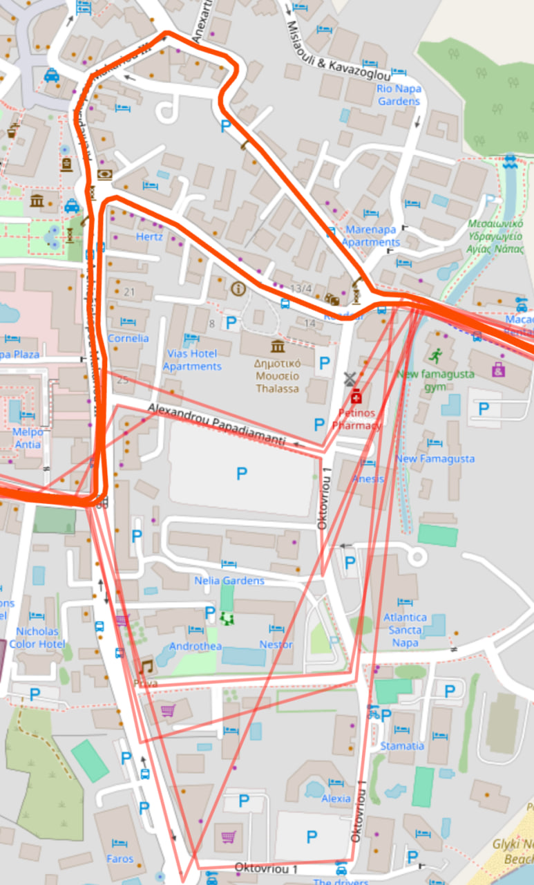
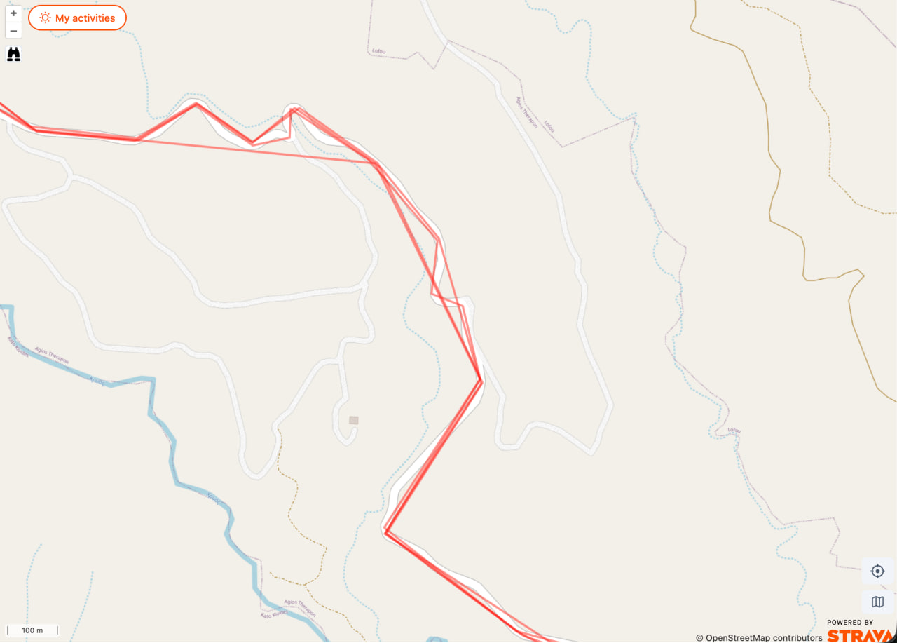
When you connect Strava, you may notice that some of your activity tracks look strange on the map: jagged, with long straight lines between corners, sometimes cutting over fields or across hills. This is not a bug — it is how Strava sends the data.

Strava activity tracks rendered with the default low-detail polyline — jagged, with long straight segments that do not follow the roads.
1. The default tracks returned by Strava — low detail, not following the actual roads.

Why this happens

Strava lets us read your activities in batches of 200 at a time. To keep these batch responses small and fast, Strava only includes a simplified version of each track — a low-resolution shape with only a few points. This is a Strava restriction, not a choice we make. The full, accurate track is not in the batch.

How we fix it

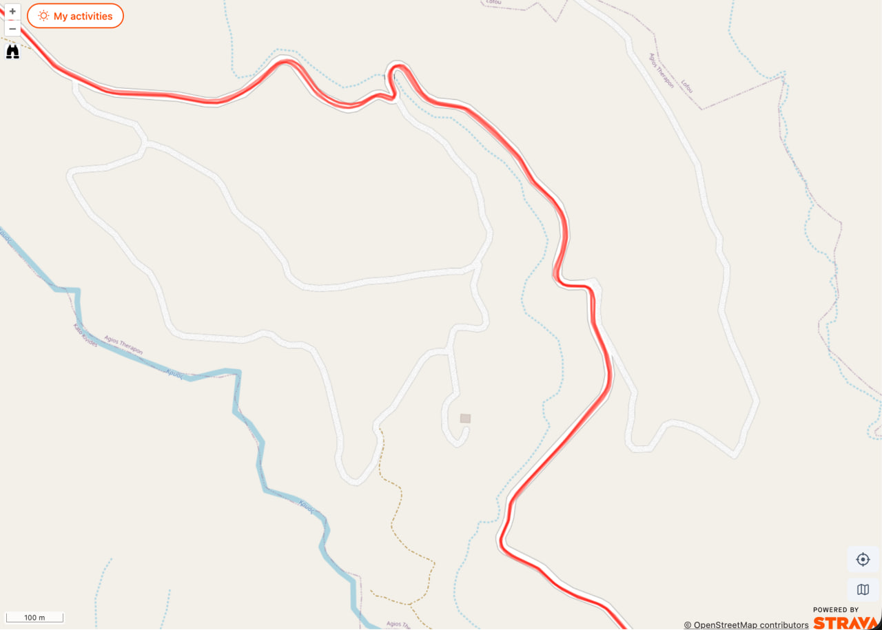
To get the accurate version of a track, we have to ask Strava for it one activity at a time. Each of those requests costs one unit of our Strava API quota. The quota is shared between all RouteCycle users and is not very high, so we cannot refresh everything at once. We update tracks gradually, in the background.

The same area after the activity tracks were refreshed — the lines are smooth and follow the road precisely.
2. The same tracks after we refresh them — smooth and accurate, following the real road.

What you will see

While the refresh is in progress, you can see a mix on the map: some tracks are already accurate, others are still the rough version. The example below shows this — the top track has been refreshed and follows the streets, while the tracks at the bottom are still the default rough lines that cut across blocks.

A map with a mix of refreshed and not-yet-refreshed Strava tracks. The top track is smooth and accurate; the tracks at the bottom are still jagged.
3. Partly refreshed: the top track is accurate, the tracks at the bottom are still the rough default.

Just give it some time. The tracks get better and better as the background refresh runs. If something still looks wrong after a few days, please email us with the route link and we will take a look.

How to check the status in the app

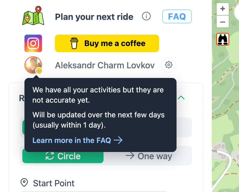
You can see the refresh status on your Strava avatar at the top of the page. When all your activities are loaded but not yet refreshed to the accurate version, you will see a yellow indicator. The whole service works normally in this state — only the heatmap is not accurate yet.

A yellow indicator on the user avatar with a tooltip: We have all your activities but they are not accurate yet. Will be updated over the next few days.
1. Yellow indicator — all activities loaded, accuracy refresh still in progress.

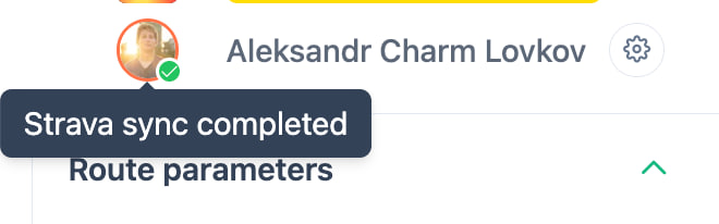
Once the refresh finishes, the indicator turns into a green check mark and you see "Strava sync completed." From this point, every track is the accurate version.

A green check mark on the user avatar with a tooltip: Strava sync completed.
2. Green check mark — all tracks are now accurate.

The full refresh can take from a few hours to a few days. It depends on the queue: how many users are syncing at the same time and how many activities you have. Users who visit RouteCycle more often get priority in the queue — you just need to open the site while connected with Strava. You do not need to generate routes for this to count.

Read more

RouteCycle has several modes. You can use them together. Here is what each one does.

Circle vs. One way

One way is the classic A-to-B route, like other apps. You pick a start and a finish, and you get a route between them. The difference: RouteCycle tries hard to avoid traffic, so it often does not pick the shortest route. It will choose small, quiet roads instead, even if the ride is longer.

Circle builds a loop that starts and ends at the same place. You only pick a start point and a distance — there is no "finish." This is the mode most people use: leave home, ride 60 km on quiet roads, come back. Building loops by hand is hard in other tools. Here it is the default.

The default ride (no toggles)

If you just build a route without turning any toggles on, you should get a good, peaceful ride — nothing fancy, but solid roads where local cyclists probably ride every day. For most people, this is already enough.

If this default mode works badly for you (sends you on bad roads or highways), then something is wrong in your area — most likely the OpenStreetMap data is incomplete or tagged incorrectly. Please contact us by email or Instagram. I would be glad to look into it and fix it.

Outside the city vs. In the city

Outside the city tries to leave the city and the traffic as fast as possible. If you start in a town, the route will go to the countryside and stay there. You should get a peaceful ride without many cities or traffic, but still with some sights along the way.

In the city does the opposite. The peacefulness of the route becomes much less important, and finding sights becomes the main goal. Use this when you visit a new city as a tourist and want a ride that shows you the best places. The route can go through busy streets if the interesting places are there.

Sights, springs, cafes

Find sights changes the route itself so it passes interesting places: castles, viewpoints, monuments, churches, parks, and so on. Right now you can't pick which categories of sights to look for — we find everything at once. Choosing specific categories is not available yet.

Find springs and Find cafes work differently. They do not change the route itself. They just show drinking water points and cafes that are close to the route you already have, so you can pick the ones you want to stop at on the way. We don't show every single one — they are spaced at least 5 km apart and have to be near the route. The idea is to give you a useful, short list, not flood the map with pins.

Stops (waypoints)

You can add up to five stops you want to visit. Stops work the same way in every mode — RouteCycle will try to add these points to the route and pick the quietest roads between each pair of stops. A common use: pick two cafes and a viewpoint, and let RouteCycle choose the roads between them.

One thing to know: sometimes the route will go to a stop and come back the same way, instead of passing through it and continuing on different roads. This happens from time to time today. I plan to improve it in a future release.

Explore new roads

Connect your Strava account. Explore new roads works the same way in every mode — on top of the normal routing, RouteCycle tries to add new (for you) pleasant roads. The route panel shows how many new kilometers each route has. This is the feature most people come back for, once they have ridden their local loops many times.

One honest caveat: today the feature can sometimes send you onto a road you skipped for a reason — a noisy highway, for example. It doesn't happen very often, but it does happen. I plan to improve this, and possibly let you pick how "adventurous" you want the new roads to be, so you can stay on the safer side if you prefer.

There is also an expected case: if you have already ridden every pleasant road in your area, the only "new" roads left will be the less pleasant ones — busy roads, 4–5 lane highways, and so on. RouteCycle has nothing else to suggest, so it suggests those. In the future I want to at least warn you when this happens, so you know that the route is rough because there is nothing pleasant left for you to discover here, not because something is broken.

Read more

Most of the roads RouteCycle uses come from OpenStreetMap. This is great in places where the OSM data is detailed and well-maintained — but it also means that if the OSM quality in your area is poor, the routes can be poor too.

A real example: in the United States, most roads are missing a very important tag called surface. Without it, I cannot tell whether a road is paved or unpaved. So a route that looks fine on the map can turn out to be a dirt or gravel road in real life. The same problem exists for things like road quality, smoothness, cycleway tagging, and access restrictions.

I have some workarounds for this. Some of them are already live, others are on my future list. It's a big separate task, and it takes time.

If you get a really bad or dangerous route — especially with no toggles turned on — please send it to me. Include:

  • The link to the bad route
  • A short note explaining what is wrong (highway, gravel, dangerous traffic, etc.)
  • If possible, a link to a good route in the same area as a reference

You can reach me by email or on Instagram. Reports like this help me improve the project a lot.

Read more

RouteCycle uses map data from OpenStreetMap and Wikidata. Roads, surface types, bike paths, and most sights come from OpenStreetMap. Extra information about castles, monuments, viewpoints and other places comes from Wikidata. Both are open projects — anyone can help improve this data. If you find a missing road or a wrong surface type in your area, you can fix it on OpenStreetMap and it will appear in RouteCycle on the next update.

RouteCycle is my personal passion project, not a big company. I built it because I wanted this tool for myself, and I thought other people would want it too.

Read more

RouteCycle is free and stays free — there's no subscription and no ad-supported tier planned. What keeps the servers and the Google Street View/Mapillary photo API running is donations and a bit of a following.

Support the project

If RouteCycle has saved you the trouble of drawing a route by hand, a coffee goes straight to hosting and API costs — nothing else.

Buy me a coffee

Follow along

New features, route ideas, and the occasional ride photo, wherever you already are:

  • @route_cycling
  • @routecycle_com
  • @route_cycling
  • r/routecycle

Read more

FAQBlogRoutesTerms & ConditionsPrivacy Policy